
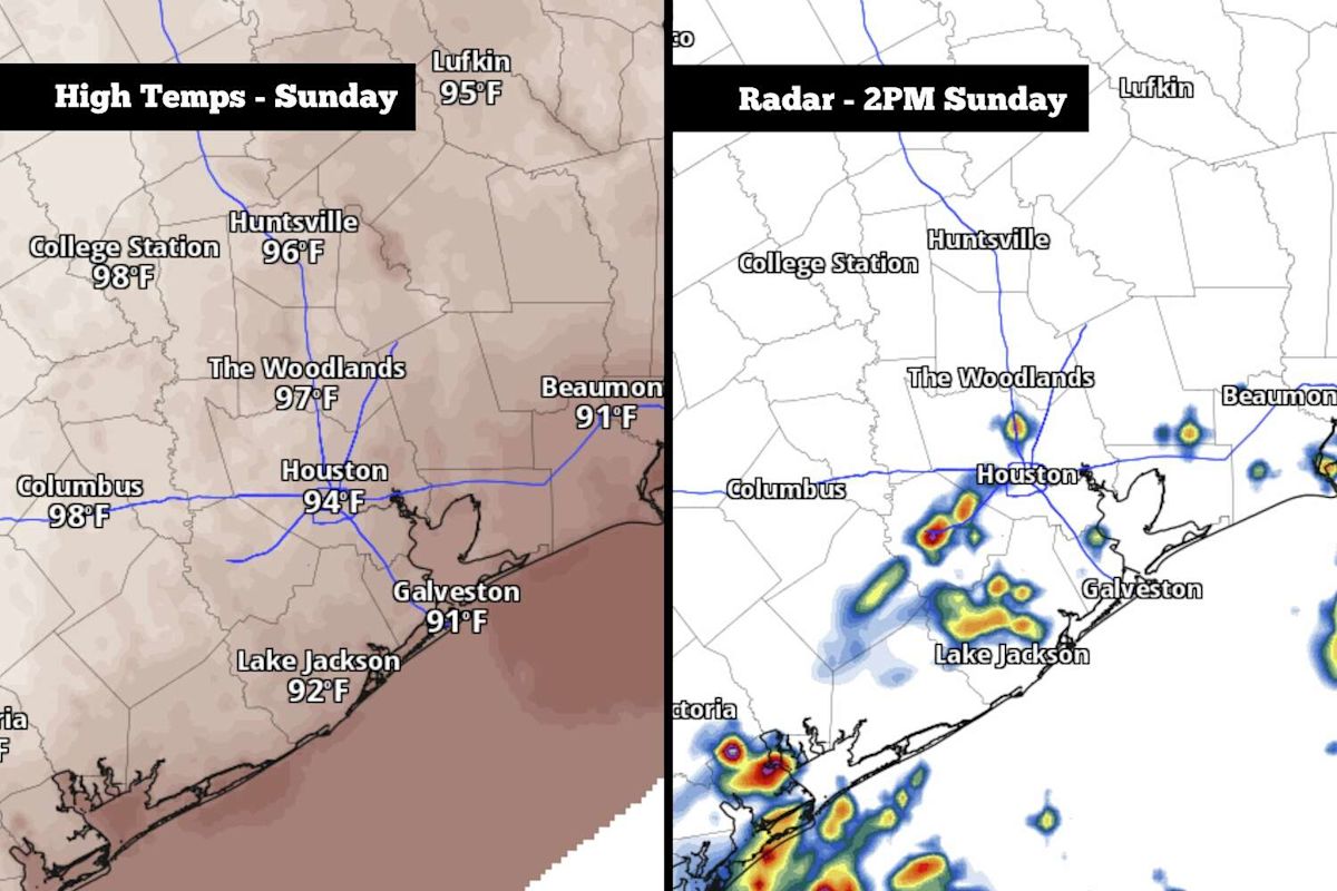
Houston residents should prepare for an uncomfortable blend of intense heat and scattered thunderstorms this Sunday, as an influx of humid Gulf air moves into Southeast Texas from the southeast. While the incoming moisture offers a chance of precipitation, forecasters note that coverage will remain irregular across the metropolitan area, leaving some neighborhoods dry while others experience sudden weather changes.
The possibility of rain comes on the heels of a prolonged dry spell that has gripped Southeast Texas throughout the late summer. Although the region enjoyed a wet spring and an active, rainy start to the summer season, the atmosphere shifted markedly over the past two months. Official records indicate that Houston has received only 2.55 inches of total precipitation since July 15, an amount that equals a mere 30 percent of the historical average rainfall typically recorded during that span.
Sunday's conditions will start off unusually warm across the Houston metro area, with morning low temperatures holding near 80 degrees. This represents an unseasonably warm start for the middle of September, a time of year when overnight and early morning temperatures in the region typically cool down closer to an average of 72 degrees.
The morning warmth will set the stage for a rapid temperature increase as the sun rises. Forecasters expect the mercury to climb quickly through the 80s and reach 90 degrees by roughly 11 a.m. This early spike will establish a very warm baseline ahead of the hottest hours of the day.
By the early to mid-afternoon, peak high temperatures are expected to top out around 94 degrees across Houston. When combined with the high levels of tropical humidity being drawn inland, the atmosphere will feel exceptionally heavy and stifling for outdoor activities.
The relentless moisture will push heat index values—the metric calculating how hot the air feels when relative humidity is combined with the ambient air temperature—up to between 103 and 105 degrees on Sunday afternoon. These elevated numbers highlight significant heat discomfort across the metropolitan area during the peak hours of sunlight.
Alongside the severe heat and humidity, atmospheric instability will trigger the development of scattered showers and thunderstorms during the warmest parts of the day. Overall rain chances for the Houston region will stand between 30 and 40 percent, with the prime window for storm formation occurring between noon and 4 p.m.
Because the convection will be driven largely by daytime solar heating, storm chances are projected to drop off quickly as the afternoon concludes. By the early evening, precipitation odds across the area will decrease to under 20 percent, leading to calmer but still warm and muggy conditions overnight.
For communities that do see precipitation, the vast majority can expect modest rainfall totals, generally staying under a quarter of an inch. A few isolated neighborhoods that encounter stronger downpours or gusty winds could measure higher accumulations reaching up to a half-inch or slightly more. Due to these limited totals, meteorologists emphasize that the risk of flooding remains very low across Southeast Texas.
Looking into the upcoming workweek, the general weather setup is forecast to remain largely unchanged. A stalled high-pressure system positioned just east of the region will maintain a firm grip on Southeast Texas, locking in several days of consistent late-summer heat and humidity.
From Monday through Wednesday, daily high temperatures across Houston are slated to reach between 92 and 94 degrees. While such readings are not unprecedented, the presence of abnormally high humidity levels for mid-September will prevent any meaningful relief during the afternoon hours.
As a result of this persistent moisture, heat index values from Monday through Wednesday will climb to between 105 and 107 degrees each day. Daily rain chances will remain low, hovering around 20 to 30 percent, and any isolated showers or thunderstorms that develop during the afternoons are anticipated to be very brief.
A minor modification in the weather pattern is projected toward the latter half of the workweek. By Thursday and Friday, the dominating high-pressure system is expected to weaken slightly, which should allow afternoon highs to ease to around 91 or 92 degrees while also permitting rain chances to edge slightly higher.
Extended forecast models suggest that a potential cold front could move into the state of Texas by next weekend. However, current meteorological projections indicate that the boundary will likely stall out before reaching Houston, meaning it will likely fail to produce a significant drop in local temperatures, though scattered storm chances will linger as the front nears.





(0)