
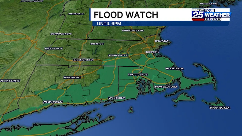
Meteorologists have issued a widespread flood watch across multiple counties in southern New England, warning residents throughout southern and eastern Massachusetts to prepare for heavy rainfall and hazardous localized flash flooding. The deteriorating atmospheric conditions prompted regional forecasters, including the Boston 25 Weather Team, to activate a Severe Weather Alert to ensure the public remains vigilant throughout the duration of the storm system.
The active flood watch encompasses eight major Massachusetts counties: Bristol, Plymouth, Barnstable, Dukes, Nantucket, Worcester, Norfolk, and Suffolk. The official alert remains in effect through 6:00 p.m. on Sunday, urging community members and local emergency management personnel across coastal areas, islands, and interior regions to closely monitor incoming storm activity.
According to regional meteorological assessments, the primary corridor of concern stretches across communities positioned along and south of the Massachusetts Turnpike. Residents navigating this major east-west transportation artery and the municipalities situated beneath it are facing the greatest probability of intense, localized downpours capable of overwhelming drainage systems and reducing roadway visibility.
Boston 25 meteorologist A.J. Mastrangelo outlined the anticipated progression of the storm, noting that a dense cluster of intense precipitation was projected to push across the region during the daytime hours. "This cluster of heavy rain will slide into Southeast Massachusetts through the late morning hours. Flood watches remain in effect until 6 p.m. along and south of the Mass Pike," Mastrangelo stated regarding the timing and trajectory of the weather system.
The prevailing meteorological pattern features widespread rain showers accompanied by embedded thunderstorms. These storm cells possess the capacity to generate narrow, concentrated bands of torrential rain that could stall or move repeatedly over the same localities, dramatically escalating the threat of sudden water accumulation on roads and low-lying ground.
Across the broader region, forecasters anticipate baseline rainfall totals to range between 0.50 inches and 2 inches. While these general accumulations represent a substantial soaking, they are generally manageable for standard regional drainage networks under ordinary conditions.
However, the primary concern stems from the high-intensity bands embedded within the larger storm complex. Meteorologists warn that within these localized ribbons of severe activity, precipitation totals could rapidly climb between 2 and 4 inches in a compressed three-hour timeframe. Such high rain rates significantly heighten the possibility of rapid runoff and flash flooding.
The National Weather Service highlighted the specific risks associated with these isolated high-volume bands, particularly given the unpredictability of exact storm tracks. While forecasting models show some variance regarding precisely where the heaviest swaths will settle, the atmospheric ingredients remain primed for localized flash flooding if these cells linger over vulnerable locations.
"While it remains uncertain whether these narrow bands of heavier rain will occur, localized flash flooding is possible, especially if it occurs over a vulnerable urban center," the National Weather Service cautioned in its official assessment. Densely populated urban environments, characterized by extensive paved surfaces and limited natural absorption, remain particularly susceptible to sudden standing water and subterranean flooding.
In anticipation of the severe weather, regional authorities are advising residents to utilize real-time safety resources and stay informed about potential utility interruptions. The Massachusetts Emergency Management Agency (MEMA) provides a dedicated online power outage viewer, allowing the public to monitor electrical service interruptions across local communities and track estimated restoration schedules provided by utility companies.
In addition to monitoring utility stability, residents are encouraged to leverage MEMA’s live weather radar and predictive forecasting platforms to track approaching rain bands in real time. These digital tools enable motorists and homeowners to anticipate localized surges in rainfall intensity before traveling or undertaking outdoor activities.
State and community organizations are also coordinating support channels to assist residents during adverse weather events. The Mass211 statewide telephone and online helpline remains accessible to connect citizens with non-emergency community resources, disaster assistance information, and vital social services during storm-related disruptions.
Broader disaster preparedness and regional oversight remain closely coordinated with the Federal Emergency Management Agency (FEMA), which works in tandem with state entities during severe weather events to ensure municipal readiness and emergency support where required.
Meteorological surveillance across the region remains under the continuous scrutiny of both the National Weather Service Boston office and the National Weather Service Albany, NY office, ensuring that any severe weather alerts, localized warnings, or sudden hydrologic advisories are immediately relayed to the public.
With the flood watch remaining active until Sunday evening, emergency officials urge drivers across Worcester, Norfolk, Suffolk, Bristol, Plymouth, Barnstable, Dukes, and Nantucket counties to avoid traversing water-covered roadways, exercise heightened caution in low-elevation zones, and remain attuned to ongoing weather updates until the heavy rain system clears the region.








(0)